|

|
|
| Product Information: | ||
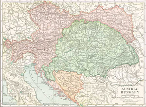
| Details: | 1910 Map of Austria, Hungary, Croatia & Slavonia, Bosnia; 1 pp; Map; 10.5x14; published: 1898; Item # FS003 This is a full color reproduction of Austria, Hungary, Croatia & Slavonia & Bosnia showing the various, mountain ranges, rivers, principal cities and roads. First published in The New Reference Atlas of the World, A New Series of Physical, Political and Historic Maps Compiled From Government Surveys and Exhibiting The Latest Results of Geographical Research .Areas include: Austria, Bohemia, Bosnia & Herzegovina, Bukowina, Carinthia, Carniola, Croatia, Dalmatia, Galicia, Hungary, Moravia, Slavonia, Styria, Tyrol, and much more. |
|